
Lake Level Changes: The Impact and Unpredictability of a Warmer Winter
By Anna Foster, Director of Programming

Aerial view of Lake Michigan and Ridges shoreline in Baileys Harbor. Photo by Brett Kosmider.
As we delight in above-average temperatures this January, it’s easy to forget how the warmer days occurring now could impact what Lake Michigan looks like next summer. While we’re complaining about the lack of ice fishing and snowmobiling (or, in my case, snowshoeing), we don’t often consider how this winter’s warmth will affect our summer swimming, fishing, and boating.
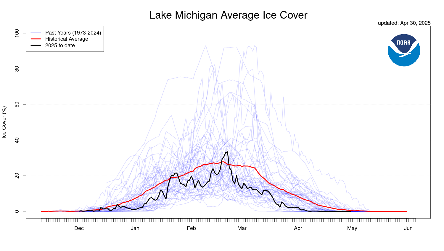
Three factors contribute to lake-level changes: precipitation, runoff, and evaporation. When we have periods with below-average temperatures, such as a polar vortex event, parts of Lake Michigan freeze over. Since the surface water is covered, less evaporation occurs. When we have warm winters, like we’ve had so far this year, more of Lake Michigan’s surface water is exposed and evaporates, decreasing lake levels.

Image from Great Lakes Environmental Research Laboratory (GLERL)
However, ice cover alone doesn’t determine lake levels. For example, lake levels could increase with high precipitation, like winter snow or spring rain events.
Why do lake levels matter?
If you were in Door County in 2019 and 2020, you might remember the damage that high water levels caused to roadways, houses, and other shorefront structures along the county. Shoreline erosion also changed the waterfront landscape in many parts of the county. At The Ridges, a newly formed ridge right along the shore of Baileys Harbor washed away. During a summer storm event, water from Lake Michigan rose so far onto Ridges beach that it flooded the parking lot. Both high and low water levels impact diverse and, in some cases, fragile ecosystems like ridges and swales. Winter conditions impact lake levels for the following year.
The Great Lakes follow a cyclical pattern of high and low water levels. However, in recent years, the pattern has become more extreme. After a period of low water levels ending in 2013, lake levels jumped, and we experienced record high water levels in 2019. When reporting on recent trends, GLISA states, “As recently as 2013, water levels for most of the lakes were very low: in January 2013, Lake Michigan-Huron set an all-time record low monthly mean water level of 576.02 feet, the lowest value on record, which dates back to 1918… In the summer of 2019, record high monthly water levels were observed on Lakes Superior, Erie, and Ontario.” (GLISA).

An infographic from the National Weather Service, 2020
What will happen in the future?
The short answer is that we don’t know. Long-term lake level models over many years vary. Scientists say we can expect more significant variability in lake levels in the long term.
The US Army Corps of Engineers projects short-term lake level model changes based on historical data on lake levels and forecasts for the next six months. These projections rely on predictions of future weather and the current conditions of the Great Lakes. The latest projections state, “The latest Great Lakes water levels 6-month forecast projects Lakes Superior and Michigan-Huron to continue their seasonal decline in January, while Lakes St. Clair, Erie, and Ontario are predicted to rise slightly.” (Army Corps of Engineers).

Predicted water levels for Lake Michigan-Huron (GLERL)
Another factor when predicting lake levels is the ongoing El Niño that the United States is experiencing this year. El Niño occurs when ocean temperatures are above 0.5 degrees Celsius for at least five months, causing a change in weather patterns throughout the winter months. This phenomenon typically causes warmer weather and less precipitation around the Great Lakes (Army Corps of Engineers).
These predictions can be incredibly helpful and accurate. However, as we know, Door County weather is anything but predictable. Only time will tell what lake levels will look like down the line.
Organizations such as the Army Corps of Engineers and NOAA’s Great Lakes Environmental Research Laboratory conduct critical research on the Great Lakes to learn more about the effects of ice cover and changing lake levels. They have incredible interactive online tools you can use to explore climate research, learn more about historical data on the Great Lakes, and view the current predictions.
Sources:
Army Corps of Engineers Monthly Bulletin
Great Lakes Integrated Sciences and Assessments (GLISA)
GLISA’s Great Lakes Assessment
NOAA’s Great Lakes Environmental Research Laboratory (GLERL)
Leave a Reply